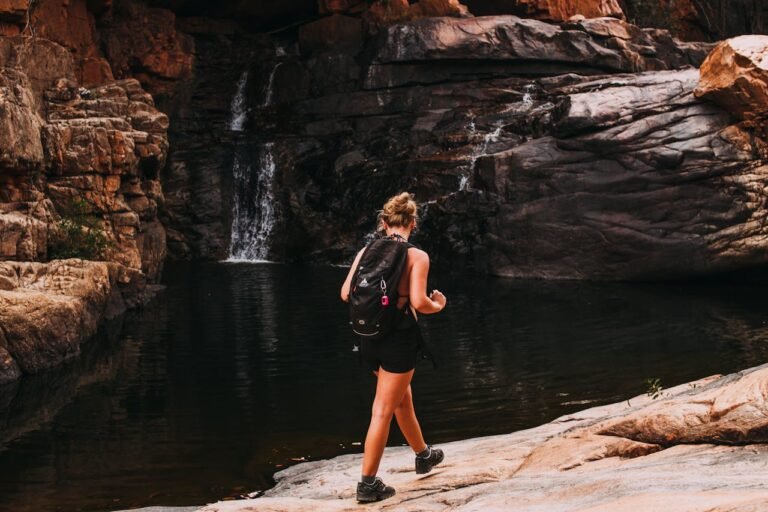
Swedish Lapland is a huge Arctic area that includes the northernmost parts of Sweden. It has some of the last wild places in Europe. Every year, thousands of people walk the Kungsleden, or King’s Trail, which goes between Abisko and Hemavan. There are also a lot of less well-known trails in the area that offer peace and quiet, beautiful scenery and real Sami cultural experiences. The land has birch forest valleys, winding rivers, barren fell plateaus and glacial cirques. In the summer, the midnight sun makes hikes bright and in the fall and early winter, the aurora borealis rewards hikers. The area’s hidden gems are only for experienced hikers who want to be alone. You need to be able to take care of yourself, find your way around and know that the weather can change from calm to dangerous in a matter of hours.
When choosing a hiking trail in Swedish Lapland, you should think carefully about how to get there (most trailheads require several bus or train connections from major cities like Luleå or Kiruna), what infrastructure is available (markings, bridges and emergency shelters) and how experienced the hiker is with Arctic weather. The following top five list includes trails that are not only beautiful but also easy to get to from Lapland’s transportation hubs and less crowded than the classic routes. There are different kinds of trails, like those that cut through canyons, go up mountains, cross river valleys and explore border areas.
Top 5 Hidden Gem Hiking Trails in Swedish Lapland
- Sarek National Park – Rapa Valley Traverse
- Vadvetjåkka National Park Circuit
- Padjelantaleden – Northern Section (Alkavare to Rissåvve)
- Lögdeälven Trail (Upper Section)
- Kaitum River Valley (Kaitum älv—to Saarivuoma)
A Closer Look at the Top 5 Hidden Gem Hiking Trails in Swedish Lapland
1. Sarek National Park – Rapa Valley Traverse
Sarek National Park, established in 1909, is often called Europe’s last true wilderness. Unlike most Swedish national parks, Sarek contains no marked trails, no bridges, no Staffed lodges and most of the 1,970 square kilometers of the area do not have cell phone service. The Rapa Valley traverse, which goes from Kvikkjokk or Saltoluokta to the park’s eastern edge near Suorva, is the best way to see Sarek. There are more than 100 glaciers and peaks over 1,800 meters high on either side of the valley. Some of these are Sweden’s tallest mountains. The six- to eight-day traverse needs people who are adept at finding their way, crossing rivers without help (which can be knee- to waist-deep depending on how much snow has melted) and finding their way in whiteout conditions.
Key Points
- No markings. To get around, you need a map (Calazo or Lantmäteriet topographic), a compass and a GPS with extra batteries.
- Crossing rivers: From July to September, you can’t use bridges to cross the Rapa River and its tributaries. The worst time is in late July, when the glaciers start to melt.
- Emergency shelters: The park has about six unstaffed STF cabins that are open for emergency use but cannot be reserved.
- You don’t need a permit to hike or camp in the wild, but you do need to follow Allemansrätten (Right of Public Access) rules in national parks.
Achievements
- It is a Natura 2000 site and one of the first national parks in Europe.
- The Sarek UNESCO Biosphere Reserve includes Stora Sjöfallet and Padjelanta.
- Listed by National Geographic as one of Europe’s top wilderness areas.
Feedback
People who have hiked a lot say that the Rapa Valley is the hardest and most rewarding place to hike in all of Scandinavia. The mountains around it are huge and there’s nothing like the feeling of being completely alone. People who have never been to Sarek before may not know how hard it is to cross rivers or how quickly the weather can change. About 2,000 people visit the park every year and most of them are from the Rapa Valley. This situation means that you can be alone outside of the month of August, which is very busy.
Contact
Website: https://www.sverigesnationalparker.se/park/sareks-nationalpark
2. Vadvetjåkka National Park Circuit
Vadvetjåkka National Park is the northernmost national park in Sweden. It’s about 40 kilometers west of Torneträsk, close to the Norwegian border. The park was built in 1920 and it grew in size in 2020. It protects a beautiful mountain landscape with Mount Vadvetjåkka (1,210 meters) and a few small glaciers. There is a clear loop trail in Vadvetjåkka that is about 18 kilometers long. Hikers who are in excellent shape and ready can do it in two to three days. Sarek doesn’t have this. The trail goes through a birch forest, over streams that were made by glaciers, up to a plateau where you can see the fell massifs around it and then back down past the park’s glacier tongues. Even though it’s easy to get to, the park only gets about 500 visitors a year.
Key Points
- Red-painted cairns (rösen) mark the main loop and the forested part has extra wooden posts.
- Accommodations: One unmanned STF cabin (Vadvetjåkka cabin) with sleeping areas and a wood stove. You don’t need to make a reservation; first come, first served.
- Best time to visit: late July to early September. Snow can stay on the plateau until July.
- Take STF’s Låktatjåkka bus from Riksgränsen train station to Låktatjåkka Mountain Station to get there.
Achievements
- Sweden’s northernmost national park, protecting the only glaciers in the country located entirely below 1,500 meters.
- In 2020, it grew to include more geological features, such as moraine systems and glacial cirques.
- Set aside as a Natura 2000 site to protect high-alpine habitats.
Feedback
Hikers praise the combination of accessibility (marked trail) and genuine remoteness (few other visitors). Visitors describe the glacier views from the plateau as unexpectedly dramatic given the park’s modest size. Some visitors report that they can find the trail markings difficult to locate in fog—competent navigation skills are still required.
Contact
Website: https://www.sverigesnationalparker.se/park/vadvetjakka-nationalpark
3. Padjelantaleden – Northern Section (Alkavare to Rissåvve)
The whole Padjelantaleden is about 160 kilometers long. It starts in Kvikkjokk in the south and ends in Ritsem in the north. It goes through Padjelanta National Park, which is Sweden’s largest national park and the Sami people’s home for a long time. The southern part (Kvikkjokk to Stáloluokta) gets a lot of foot traffic, but the northern part (Alkavare Chapel to Rissåvve) is much quieter. This 45-kilometer stretch goes over the open fell plateau of Padjelanta and lets you see some of Sweden’s tallest peaks, such as Sarektjåhkkå, Ålkatj and Áhkká. The trail goes through places where the Sami people have traditionally herded reindeer. In the summer, hikers share the land with herds of free-roaming reindeer.
Key Points
- The wooden posts and cairns are easy to see from a long way away across the treeless plateau because they have two red crosses on them.
- Accommodations: STF huts (Alkavare, Stáloluokta, Rissåvve) with a warden service from mid-June to mid-September. They sell dried food and have simple bunk beds.
- Cultural heritage: The Sami community restored and now takes care of Alkavare Chapel, which is Sweden’s highest church and was built between 1788 and 1790.
- How to get there: You can take a bus from Gällivare or Jokkmokk to get to the northern trailhead at Ritsem. Kvikkjokk is the way to get to the south.
Achievements
- Padjelanta is a UNESCO Biosphere Reserve and part of the Laponia World Heritage Site (inscribed 1996).
- The area contains Sweden’s largest continuous alpine heath ecosystem.
- Alkavare Chapel is protected as a listed historic building (byggnadsminne).
Feedback
Hikers like the wide-open, almost lunar landscape and the feeling of walking through living Sami cultural territory, where they often see herds of reindeer. The northern route from Kvikkjokk is less busy than the southern route, so it’s a better place to be by yourself. Some people say that the open plateau doesn’t protect you from the wind, so you need to know how to layer your clothes and set up a tent.
Contact
Website: https://www.swedishtouristassociation.com/areas/padjelanta
4. Lögdeälven Trail – Upper Section
The Lögdeälven Trail (Lögdeälvsleden) follows the Lögde River from the east, near the Norwegian border, through boreal forest and swamp systems. The whole trail is about 90 kilometers long. The upper part, which goes from the river’s source lakes (Övre Gittjesjaure area) to the village of Rävabäcken (about 35 kilometers), doesn’t get many visitors, though. It has a well-kept trail and regular bridge crossings. This part goes through the Vindelfjällen Nature Reserve, which is one of the largest protected areas in Europe, covering about 5,600 square kilometers. You can really feel like you’re in a forest and by a river without all the people who are usually on the Kungsleden. The land isn’t too hard; it has rolling hills, marsh boardwalks and old-growth pine forests.
Key Points
- Markings: Wooden posts painted orange and some small stone piles; well-kept bridges over big tributaries.
- Access: The northern trailhead is close to the border with Norway and can be reached by bus from Hemavan (E12 highway).
- Fishing: The Lögde River is a well-known place to catch sea trout and salmon. You can get fishing permits nearby.
- From July to mid-September, when the water levels are safest, is the best time to camp near the river.
Achievements
- Vindelfjällen Nature Reserve is one of the biggest protected areas in Europe. It has Sweden’s biggest old-growth forest systems.
- The Lögdeåns Vattenråd (local water council) keeps the trail up with the help of volunteers.
- It was chosen as a Natura 2000 site to protect populations of Atlantic salmon and freshwater pearl mussels.
Feedback
People who have hiked in the forest before say they like how quiet the trail is and how beautiful the old-growth forest is, with pine trees that are thought to be over 400 years old. When it’s hot outside, the best places to swim are wild camping spots along the river. Some people who have been there say that some parts of the trail, especially the marsh boardwalks, can become overgrown. They suggest bringing a GPS as a backup. Reputation: great for hikers who like the boreal forest better than the treeless fell terrain.
Contact
Webaite: https://www.lansstyrelsen.se/vasterbotten/besoksmal/naturreservat/vindelfjallen.html
5. Kaitum River Valley (Kaitum älv—to Saarivuoma)
The Kaitum River Valley is to the southeast of Kiruna. It flows east through a wide, U-shaped glacial valley that comes from the Kebnekaise massif. The Kaitum Valley trail from Ladtjojaure (accessible via the E10 highway) to Saarivuoma differs from the popular hiking areas near Kebnekaise. It goes through birch forests, over open fells and along the river’s many braided channels. The trail doesn’t have any signs, but it follows natural paths. The valley floor and the river are easy to follow, so you won’t get lost. This region is where the Sami traditionally herd reindeer and hikers often see herds moving around in late summer. The trip to Saarivuoma is about 55 kilometers long and should take four to six days.
Key Points
- No markings. To find your way, you need a map and compass. The valley shape and the river are the main points of reference.
- Getting there: The trailhead is at Ladtjojaure, which you can get to by taking the road to Nikkaluokta (turn off the E10 about 70 kilometers east of Kiruna).
- No huts; only wild camping. There are a few traditional Sami njälla (food storage huts), but people can’t go inside them.
- Wildlife: moose, brown bears (which are very rare), wolverines (which are very rare) and many birds, like the rough-legged buzzard and the golden eagle.
Achievements
- The valley is in the Ráhpattan–Sjaunja area for reindeer grazing, which is one of the best places in Sweden for herding.
- Next to the Sjaunja Nature Reserve, which protects one of the biggest mire complexes in Europe.
- The Kaitum River is a watercourse of national interest because it is important for both the environment and culture.
Feedback
Hikers say the Kaitum Valley is as wild and quiet as Sarek, but the ground is easier to walk on and the rivers easier to cross. The walls of the valley get closer together near Saarivuoma, which makes for a dramatic view at the end. There are no marked trails or huts, so it’s completely quiet, but you need to be self-sufficient. Reputation: best for experienced hikers who are good at finding their way and crossing rivers on their own.
Contact
Website: https://www.lansstyrelsen.se/norrbotten
FAQ
What is the best month for hiking these trails?
The best time to go is from late July to mid-August, when there is no snow, the weather is stable and there aren’t many mosquitoes (the worst time for mosquitoes is late June to mid-July). September has beautiful fall colors (russet hues in birch forests), but the nights are much colder (below freezing) and the days are shorter. There is often still snow on the Vadvetjåkka and Sarek trails until July.
Do I need special permits or registration for these trails?
You don’t need a permit to hike or camp in the wild in Swedish Lapland, even in national parks, except in certain areas where camping is not allowed (not on these trails). But the Swedish Environmental Protection Agency (Naturvårdsverket) says that you should tell someone where you’re going and when you plan to be back since most trails don’t have cell phone service. It is strongly recommended but not required for Sarek to register with the Sarek Visitor Centre in Kvikkjokk.
What equipment is necessary for these lesser-known trails?
You need a topographic map (Calazo or LMT), a compass, a GPS or satellite messenger (Garmin inReach is best), a waterproof tent that can handle high winds (staked on gravel or snow), a sleeping bag rated for at least -5°C, a stove and fuel (some areas don’t allow wood collection), a water filter (as a backup to boiling), river-crossing sandals (neoprene boots are optional but recommended) and full rain gear (breathable membranes aren’t enough for long periods of time). In Lapland, it rains a lot, so wear rubber or heavy PU-coated gear.
How do I reach these trailheads without a car?
You can get to all of the trails by public transportation, but you need to plan ahead. The usual way is to take a train to a major hub (like Kiruna, Gällivare, Jokkmokk, or Hemavan) and then a bus to the trailhead. You can only get to Sarek by bus from Jokkmokk to Kvikkjokk (April to September). To get to Vadvetjåkka, you need to take a bus to Riksgränsen (or a train from Narvik or Stockholm) and then walk 5 km to the site. To reach Kaitum Valley, take a taxi from Kiruna or a bus to Nikkaluokta, then walk. Look at ResRobot. SE and Länstrafiken Norrbotten/Västerbotten provide schedules that change with the seasons.
Are these trails suitable for solo hiking?
Yes, but only for experienced hikers who can navigate, rescue themselves and have the right gear. Sarek and the Kaitum Valley, in particular, require people to be able to cross rivers on their own. Solo hikers must be able to cross chest-deep, fast-moving water without help. The northern part of Vadvetjåkka and Padjelanta is better for strong intermediate solo hikers. It is highly recommended that you carry a satellite messenger (Garmin inReach or Zoleo) with you when you travel alone in all areas.
What wildlife safety considerations should I be aware of?
There are brown bears in all areas except the highest fell zones, but they are not very common. Basic safety tips: Keep food and scented items in bear-proof containers or hang them at least 4 meters above the ground and 100 meters from camp. During rutting season (late September to October), moose are common and can be dangerous, so keep your distance. Arctic foxes (which are rare) and wolverines (which are very rare) don’t hurt people. There are no poisonous snakes in Swedish Lapland.
Are there any huts or lodges available for accommodation?
There are three STF huts with wardens in the northern part of Padjelantaleden during peak season: Alkavare, Stáloluokta and Rissåvve. Vadvetjåkka has one cabin that is not staffed (first come, first served). Sarek has six emergency cabins that are not manned, but they are not ideal places to stay. Only use them as intended, which is as emergency shelters. There are no huts in Lögdeälven or Kaitum Valley; only wild camping.
How do the mosquito conditions compare between these trails?
The open plateau of Padjelanta has a moderate number of mosquitoes because of the constant wind. The lower valleys can have many mosquitoes. Vadvetjåkka and Sarek’s Rapa Valley have many mosquitoes (4 out of 5) until the first frost in August, when they drop off sharply. Lögdeälven by the river has many mosquitoes (4 out of 5 stars) because there is standing water in nearby mires. It is best to wear permethrin-treated clothing and a head net. There are many mosquitoes in Kaitum Valley, but the open areas are windy enough to help.